

| Final Statistics: Alex & Maz | Total distance: 93,550km |
| Furthest Point: Rotorua, NZ | Now settled in Sydney, Australia |
| Final Statistics: Martin | Total distance: 79,698km |
| Furthest Point: Hobart, Australia | Now settled in Bristol, UK |
Serbia & Montenegro
|
 Serbia & Montenegro
|
|
|


| Arrive: | Fri 19th Aug 05 | Depart: | Wed 24th Aug 05 |
| Days: | 5 | Approx km: | 400 |
| Capital: | Belgrade | Currency: | Dinar (YUN) |
| Weekend: | Sat/Sun | Time Zone: | GMT +1 |
| Int. dial code: | +381 | Language: | Serbian, Albanian, Hungarian |
| Visa Required: | No | Religion: | Serbian Orthodox, Muslim, Roman Catholic |
| Side of road: | Right | Best time to visit: | Summer |
| Diesel Price: | US$ 0.96 | Activities: | Sightseeing, Hiking, Rafting, Diving Adriatic |
Click here to see our mission statement in Serbian.
Diary Entry: 18th-24th Aug 2005 - Hello my name is Cyril and I'll be your new alphabet
Diary Entry: 20th-22nd Aug 2005 - No Problem - no honestly
Photo Album for Serbia & Montenegro
Country Highlights En Route
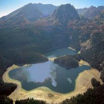 Durmitor National Park
This breathtaking national park was formed by glaciers and is traversed by rivers and underground streams. Along the Tara river canyon, which has the deepest gorges in Europe, the dense pine forests are interspersed with clear lakes and harbour a wide range of endemic flora.
Belgrade
Belgrade is situated at the place where the Sava joins the Danube. Belgrade is one of the oldest cities in Europe and, beside Athens, the greatest urban whole of the Balkan Peninsula. The oldest archaeological artefacts from Belgrade area date back to the fifth millenium B.C. The members of a Celtic tribe founded Singidunum in the III century B.C., while the first record of the name Belgrade dates back to 989 A.D. During its long and tumultuous history, Belgrade has been conquered by 40 armies, and 38 times it has been raised up from the ashes.
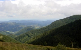 Kopaonik
Kopaonik was declared a national park in 1981. It spreads on the upper highest parts of Mt. Kopaonik, the biggest mountain in Serbia. The national park spreads on 12,000 hectares. A vast high mountainous and relatively flat region at an altitude of about 1,700 meters forms the basis of this national park. This central Kopaonik plateau is called Suvo Rudiste. It is surrounded by mountain peaks. To the north and northwest of this plateau stretches Banjski Kopaonik below which is the well-known Josanicka Banja spa with its strong springs whose waters reach the temperature of 88 degrees Celsius. Directly below the Suvo Rudiste plateau starts the attractive and picturesque valley of the Samokovska River, characterized by its steep run, numerous rapids, falls and gorges. 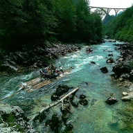
Rafting River Tara
You can go rafting by boat or wooden raft along 100km of the most beautiful and exciting part of the Tara. You leave from Splaviste, where you can see Ljutice falls, the Tara Bridge (150m high), the old Roman road, and Lever Tara. Then, you pass the wild Funjicki and Bijele ploce rapids, Miso's spring where the canyon is the deepest (1100m), beneath Curevac peak (1650m), the falls of the Draga river, and Radovan luka. The following scenery simply takes your breath away by its beautiful nature and the strength of the rapids. There are Tepacki falls, the Susica canyon,and Bailova sige. The rafting ends at Scepan polje.
 Previous: Croatia
| All content copyright � overland-underwater.com - please do not use without permission. |
| Comment from One Dollar |
| Really envy of what you guys are doing. Really a great great luck and best wishes. Remember it is not the destination but the journey itself.................... Cheers |
| 07 Jul 2006 @ 19:38:28 |